Jul 25, 2018
Celebrate Mountain Day by Hiking Around Aichi

One great thing about living in Japan is the fact that there are so many holidays. Between New Year’s Day on January 1st and the Emperor’s Birthday on December 23, there are a further 15 national holidays observed. One recent (2016) addition to the calendar is Mountain Day, or ‘Yama no he’ (山の日), on August 11. According to the legislation that enacted the law, Mountain Day was created to give the Japanese public “opportunities to get familiar with mountains and appreciate blessings from mountains”
But this need not be restricted to the locals. As a national holiday, many of you will be given the day off too, so why not get out and explore some of the mountains in the Aichi and Gifu areas. Here we will have a look at a few that you can try out, relatively easily.
Mt Gozaisho
An hour outside of Nagoya is Gozaisho-Dake’s 1,210 meter peak. It is a great hike up the highest peak in the Suzuka Mountain Range, and affords stunning views of Shiga and Mie Prefectures, the beautiful snow capped Japanese Alps, as well as the waters of Ise Bay and Lake Biwa. On a particularly good day you may be able to catch a glimpse of Mount Fuji. This is a great spot to visit whether hiking or riding up the rope way gondola to the top. It is a beautiful place, and it even has a restaurant and gift shop at where you can sit, relax and even get some curry and coffee.
- Getting there: Yunoyama onsen station is accessible from the Kintentsu line from Nagoya station (about 70 minutes), or you can take a bus from Sakae station . From there, it is a simple 10 minute bus ride to the rope-way.
Mt Ena
Often used for those who want to get some practice in before climbing Fuji, this mountain on the Gifu and Nagano border can be tough at times so you should be prepared for a little exertion.
From the parking lot at Misakatouge, take the 90 minute trail towards Oobanyama (大判山), the peak of which has beautiful panoramic views of the Minami and Chuo Alps, as well as Mt. Ondake and Mt. Ena in front of you. From the peak, the trail curves toward the right and down before flattening and then climbing again until the summit ridge. It should take about 2 hours or so to reach the Ena ridge line, as the final climb is quite steep. Once you reach the ridge, the trail will veer to the left and become flat and easy. After about 20 minutes or so, you’ll come to a mountain hut named Enasan-sanchou-goya. By climbing the rock behind the hut you’ll be rewarded with terrific views of the Minami Alps and Mt. Fuji. The true summit is another 10 minutes or so past the hut, and there’s a small shrine at the top, but no view. Be warned, there are no water sources at all on this hike.
- Getting there: Take the JR Limited Express Shinano train for Nagano and get off at Nakatsugawa station. From the station, there is no bus service to the trailhead so either take a taxi (around 7000 JPY) or try your luck hitching.
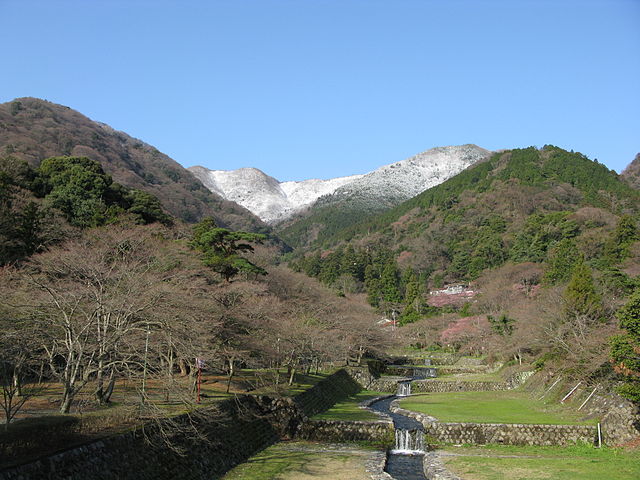
Mt Yoro
For something a little easier you could head to Mt Yoro in Gifu to see the beautiful and iconic Yoro waterfall, which is just a 30 minute walk from the station. Should you wish you can take a ropeway to the 859m summit, though if you are feeling fit there is a two to three hour climb to the top. It is one of the best areas near Nagoya to see forests, and there is a small chance that you could see wild deer, boars or even monkeys.
- Getting there: The train takes around 70 mins from Nagoya to ‘Yoro’ station. Take the JR Tokai line towards Maibara and Ogaki where you should change for Yoro.
Mt. Ibuki
Mt. Ibuki in Shiga Prefecture is an relatively moderate hike although on busy days, this may be made more difficult as you spend your time trying to squeeze past groups of school children. The trail is very much open to the elements (pack plenty of sun cream), although this does mean that as you climb the views can be superb.
Unlike the Mt. Ena climb, there are plenty of places to stop and get drinks, with many vending machines along the way, and at the summit there are shops and restrooms, and you may even see the odd pair of high heels of those who have driven to the top. If you are an experienced climber this may not be the thing for you, but for a beginner it might be a good place to begin your mountain love affair.
- Getting there: The nearest station to the trailhead is Ominagaoka Station. It’s a 4.9 km walk from the station to the trailhead, but if you don’t like the idea of walking, you can also catch the bus bound for Ibukiyama Tozanguchi to get you to the trailhead.
CHIC Nagoya Hiking Group
If you are truly interested in hiking around the area, give the guys at Chubu Hiking International Club (CHIC Nagoya) a shout. They are a group of Japanese and foreign likeminded hikers who organize trips for all levels of hiker. Their Facebook page is here.
Mark Guthrie
Photo: flickr.com – Mount Yoro viewed from Fudo Bridge, Yoro Park in Yoro Town, Gifu Prefecture, Japan by Kikuhiko Mizusaki – (CC BY-SA 3.0)
Bert Wishart editor
Novelist, copywriter and graduate from the most prestigious university in Sunderland, Bert whiles away his precious time on this Earth by writing about popular culture, travel, food and pretty much anything else that is likely to win him the Pulitzer he desperately craves.
About the author